
Executive assessment
The central technical finding is that the Lefkada incident should not be modelled as a Ukrainian naval drone that suffered a generic malfunction in the Black Sea and, as a consequence of that malfunction, somehow travelled accidentally into the Ionian Sea, because the combination of platform range, route geometry, Turkish-Straits navigation, the later Greek forensic reporting and the wording of Athens’ diplomatic protest makes that interpretation extremely difficult to sustain; the substantially more coherent reconstruction is that the craft had already been deliberately deployed into the Mediterranean, probably for an operation against Russian or Russia-associated maritime traffic, after which a comparatively ordinary local failure in the command-and-control chain — with Greek reporting identifying water ingress into the electronics as the probable initiating cause — deprived its operator of control and allowed the USV to enter Greek waters and eventually become trapped near Lefkada. Reuters reported on 15 May that Greek investigators believed the craft had lost orientation because of a technical malfunction and were examining metadata, fuel state and a possible launch from shore or a mother ship, while later Greek reporting based on the completed Hellenic defence investigation identified the platform as a Mamai and placed its preceding trajectory in the maritime area south of Italy, relatively close to Sicily. [1]
Our present assessment is therefore materially different from the proposition that “a machine fault explains why a Ukrainian USV was found so far from the theatre”: the fault probably explains why the mission terminated at Lefkada, but it does not satisfactorily explain why the platform was operating in the central Mediterranean in the first place. The distinction is not semantic, because if the Greek GPS reconstruction is substantially correct, the geography of the mission was intentional whereas the terminal navigation outcome was accidental, which converts Lefkada from evidence of an extraordinarily severe autonomous-navigation failure into evidence of a Mediterranean Ukrainian operation that subsequently suffered a technically plausible C2 failure. Greece’s subsequent diplomatic language is consistent with precisely this interpretation, since Athens protested against the extension of military operations into the Mediterranean rather than characterising the incident merely as an accidental migration of a Black Sea weapon. [2]
The second important conclusion is that there is no publicly defensible fleet-wide “Ukrainian USV failure rate” in the statistical sense, because neither the SBU, Defence Intelligence nor the Ukrainian Navy publishes the number of sorties launched, aborts, mechanically lost vehicles, command-link failures or systems recovered without reaching their targets, while publicly visible combat successes are subject to obvious survivorship and disclosure bias. The June 2026 Constanța incident is nevertheless extremely valuable because the Romanian Ministry of National Defence subsequently established that Ukraine had lost communications with four Sargan-3000 USVs near Sevastopol during the afternoon of 4 June, that the operators were then unable to control their trajectories or restore communications, and that programmed self-destruction subsequently eliminated all four systems, including one inside Constanța harbour; because all four were affected in the same operational episode and Ukraine attributed the event to Russian electronic warfare, the incident is evidence for a common-mode C2 vulnerability rather than evidence that four independent hardware failures occurred simultaneously. [3]
For reliability planning rather than historical measurement, we would assign a broad 2–15 per cent engineering prior to a hardware-originated mission-degrading failure during a long 24–40 hour sortie by a rapidly iterated, partly COTS-derived combat USV, with the lower end corresponding to a mature integrated platform and the upper end to prototype-like equipment operating under saltwater vibration and thermal stress; mathematically, an assumed effective integrated-system MTBF between 200 and 2,000 hours produces a 1.8–16.5 per cent probability of at least one hardware failure during a 36-hour mission, although these MTBF values are explicit analytical assumptions rather than Ukrainian measurements. Once deliberate EW, satellite-link interruption and GNSS interference are included, a Black Sea mission-degrading C2/navigation-event probability in the order of 10–30 per cent is a reasonable stress-test band rather than an observed rate, and the Constanța event demonstrates why correlated common-mode failures can dominate a reliability calculation that would otherwise concentrate excessively on individual components. RUSI has repeatedly emphasised both the heavy use of commercial components in Ukrainian maritime drones and the extraordinarily rapid iterative cycle characteristic of Ukrainian unmanned warfare, conditions which produce cost and adaptability advantages but do not imply the environmental qualification or configuration stability associated with traditional naval procurement. [4]
For the specific Lefkada craft, however, the conditional probability distribution is much narrower because there is forensic information about the symptoms: Greek reporting states that electrical power remained available for roughly ten hours after discovery, that the craft had apparently been moving in circles, that there was no visible attempt by the operator to evade fishermen or Coast Guard personnel, that the explosive triggering system had not been activated, and, in the later account of the completed investigation, that water intrusion into an electronics unit probably caused a communications and remote-control failure. On that evidence, we assign approximately 45–60 per cent conditional probability to water-ingress/electronics failure as the dominant initiating cause, around 8–25 per cent to an external communications-denial event including RF or SATCOM disruption, approximately 5–18 per cent to a primary navigation failure involving GNSS/INS, and materially lower probabilities to propulsion, steering and general power failure, because those latter mechanisms fit the observed persistence of electrical operation and uncontrolled movement less well. [5]
The Black Sea-to-Lefkada hypothesis performs particularly badly under route analysis. Using a realistic maritime route from Sevastopol through the Bosphorus, Marmara Sea and Dardanelles and then around the Peloponnese to Lefkada gives approximately 1,660 km, while a departure from Odesa gives approximately 1,740 km; these figures are roughly twice the publicly stated 833 km range of the MAGURA V5, around 1.7 times the 1,000 km range publicly advertised for the earlier Sea Baby and still about 11–16 per cent beyond the more than 1,500 km range claimed for the October 2025 upgraded Sea Baby, even before allowing any fuel reserve, evasive routing, currents or loitering. The Turkish Foreign Ministry itself describes the Turkish Straits as exceptionally challenging because of strong currents, sharp turns and changing weather, which means that a craft suffering a genuine localisation, steering or autopilot failure before reaching the Bosphorus would have an extremely small probability of fortuitously completing both straits, crossing the Aegean, rounding southern Greece and arriving near Lefkada. [6]
There is an important exception which, given our own work on autonomous command architectures, deserves to be made explicit: a USV that loses only its beyond-line-of-sight command channel while retaining a valid GNSS/INS solution and a functioning waypoint autopilot can continue for hundreds of kilometres, and Ukrainian operators have publicly described MAGURA missions in which much of the transit can be pre-programmed before human control becomes important in the terminal phase. Such a vehicle is not, however, “lost” in the navigational sense; it is executing its stored mission plan without supervisory C2, which means that if it subsequently travels through the Turkish Straits towards the Mediterranean, the much more important analytical question becomes why the Mediterranean route was already contained in its mission logic. [7]
The Romanian Sargan precedent also alters the self-destruct question considerably, because it proves that Ukraine can know that a group of USVs has lost communications, can know the programmed self-destruction interval and can warn a neighbouring NATO navy even while being unable to cancel the self-destruction sequence; it does not prove that Ukraine retains independent live tracking after the principal link disappears, nor that Mamai uses the same architecture, and it specifically shows that a remote destruct command is not necessarily possible once C2 has been lost. The Romanian chronology is nevertheless embarrassing from a safety-governance perspective, because the communications were lost during the afternoon of 4 June whereas the Ukrainian warning to Romania was transmitted at 09:54 on 5 June, after Romanian authorities had already detected the object in Constanța at 06:20, which indicates that the pre-existing cross-border lost-USV notification architecture was not immediate and was sufficiently inadequate that Romania subsequently requested a permanent technical channel and geographically safe self-destruction programming for future Ukrainian naval drones. [8]
Finally, we consider partial diplomatic and intelligence sanitisation of the Lefkada operation not merely possible but highly probable, although this is very different from alleging that Greece and Ukraine fabricated the existence of the reported malfunction. Athens had powerful reasons to withhold the raw navigation log, command timestamps, satellite-terminal identifiers, crypto material, engine-hours/fuel data, probable launch platform and suspected target, while Kyiv had even stronger operational reasons to conceal any mother-ship network, Mediterranean support infrastructure and tanker-targeting intelligence; at the same time, Greece publicly identified Ukrainian responsibility, lodged two diplomatic démarches, informed NATO and EU officials and explicitly objected to the transfer of military operations into the Mediterranean, while Ukraine subsequently apologised, which makes the hypothesis of a comprehensive coordinated cover-up significantly less plausible than the much more ordinary proposition that governments disclosed the politically necessary conclusion while withholding the operationally sensitive evidence underlying it. [2]
Our structured posterior, which is an analytical probability distribution rather than an empirical frequency estimate, is consequently approximately as follows:
| Hypothesis | Central posterior | Assessment |
| Deliberate Ukrainian Mediterranean operation, probably directed against Russian/Russia-linked shipping, followed by a genuine local C2/navigation failure | 70% | Most consistent with Greek GPS reporting, reported electronics failure, diplomatic protest and established Ukrainian Mediterranean targeting |
| Deliberate Ukrainian Mediterranean loitering/ambush mission in which the “fault” was secondary, exaggerated or absent | 10% | Possible, but weakened by reported water-ingress evidence and absence of operator reaction |
| Ukrainian Mediterranean staging/transport operation followed by accidental release or mission-independent malfunction | 8% | Technically possible, but less consistent with suspected Russian maritime target |
| Black Sea launch followed by fault-induced autonomous/drifting transit all the way to Lefkada | 3% | Technically very weak because of range, route and Straits geometry |
| Capture, reuse or deliberate false-flag employment by Russia or another actor | 3% | Possible in principle but presently unsupported by the public forensic record |
| Other or unresolved | 6% | Retained because the Greek technical report and raw telemetry are not public |
Our confidence is high that the drone was Ukrainian-origin, medium-high that it was a Mamai-family platform, medium-high that it was deliberately deployed in the Mediterranean before the terminal malfunction, medium that its intended mission concerned Russian or Russian-associated shipping, medium-high that a genuine C2/electronics failure occurred, very low that an ordinary Black Sea mission failure alone explains its arrival near Lefkada, and high that substantial operational details remain classified.
Ukrainian USV technical baseline
The first methodological problem is that “Ukrainian naval drone” does not designate a homogeneous fleet, because at least three major Ukrainian organisations have developed partly independent maritime-unmanned ecosystems — the Security Service of Ukraine with Sea Baby and Mamai, Defence Intelligence with the MAGURA family, and the Ukrainian Navy with Sargan-3000 — while configurations have changed rapidly enough that a 2023 Sea Baby, a 2025 Sea Baby and a 2026 Sargan should not be assumed to share either the same navigation stack or the same fail-safe logic. RUSI’s broader assessment of Ukrainian unmanned warfare describes precisely this rapid iterative model, in which operational use and short upgrade cycles replace the traditional expectation of a stable production configuration, while the SBU’s October 2025 presentation showed that Sea Baby itself had evolved from a one-way explosive craft into a heavier, reusable, remotely controlled multi-role platform. [9]
A second distinction concerns autonomy, because the open record does not support describing the Lefkada Mamai as an “AI-commanded” system in the strong sense of autonomous mission-level decision-making. MAGURA has publicly been described as capable of pre-programmed transit with remote operator supervision and manual terminal engagement, while the upgraded Sea Baby was said in 2025 to incorporate AI-assisted friend-or-foe and targeting functions; there is no equivalent public evidence that the recovered Mamai delegated target selection or strategic route decisions to an onboard AI agent, and the technically appropriate architecture for the analysis therefore remains conventional hierarchical autonomy — low-level stabilisation and actuator control, waypoint/navigation autopilot, remote mission supervision and potentially terminal human control — rather than an autonomous artificial agent improvising its own Mediterranean mission. [10]
| Family / principal operator | Propulsion and energy | Public range, speed and endurance | Navigation and autonomy | Communications, EW and fail-safe | Confidence |
| Mamai / SBU | Public primary data on engine and fuel capacity remain sparse; imagery analysis indicates a planing high-speed architecture, while exact hydrocarbon-fuel and electrical-storage figures are undisclosed | SBU publicly identified Mamai in 2023 as capable of approximately 110 km/h maximum speed; a reliable official range figure has not been published | Precise GNSS/INS architecture is not publicly documented; Lefkada forensic reporting confirms onboard GPS/mission data sufficiently rich for Greek investigators to reconstruct previous movement | Specialist analysis identifies satellite-communications and EO equipment on known Mamai configurations; no reliable public specification exists for lost-link or self-destruct logic on the Lefkada configuration | Medium on identity/speed; low on detailed C2 and endurance. SBU information via Ukrainska Pravda and Greek forensic reporting. [11] |
| MAGURA V5 / HUR | Small planing hull using COTS/recreational-powerjet-derived propulsion; exact fuel capacity undisclosed | Approximately 22 kn/41 km/h cruise, 42 kn/78 km/h maximum, roughly 450 nmi/833 km range; public specifications have cited up to 60 h autonomy | Automatic GNSS, inertial and visual navigation; autopilot; multiple video streams; operators have described pre-programmed transit followed by closer human control near the target | Redundant communications have been publicly described, with specialist sources reporting satellite communications or mesh-radio/repeater options; detailed autonomous destruct logic is not publicly established for V5 | Medium-high; specifications originated in Ukrainian export/public presentations and are consistent across specialist sources. [12] |
| Sea Baby, 2024 configuration / SBU | Ukrainian government fundraising data state a 400 hp engine; specialist examination describes waterjet-type configurations, while exact tank volume and fuel curve remain undisclosed | Government-published 2024 figures: 90 km/h maximum, up to 1,000 km range, up to 850 kg combat load | Remote operation with onboard autonomous navigation functions; detailed INS specification was not publicly released | SATCOM/remote-video control forms part of the operational architecture; subsequent versions incorporated capture-denial self-destruct | High for published headline specifications, lower for internal architecture. [13] |
| Sea Baby, upgraded 2025 configuration / SBU | Larger/heavier modular configuration; detailed fuel profile not public | SBU told Reuters that the revised system could exceed 1,500 km and carry up to 2,000 kg | SBU claimed AI-assisted identification/targeting functions in addition to remote control, while a demonstration showed shore operators controlling the craft using live video | SBU publicly confirmed a self-destruct mechanism intended to prevent enemy capture; exact lost-link timer, independent destruct channel and geofencing logic remain classified | High for SBU-announced capability, medium for operational performance because public figures are manufacturer/operator claims. [14] |
| Sargan-3000 / Ukrainian Navy | Reliable official propulsion, fuel and performance specifications have not been publicly released, despite numerous unsupported specifications circulating online | Range, cruise speed, payload and endurance should presently be treated as undisclosed rather than reproducing unverified figures | Constanța demonstrates that the craft can continue moving after loss of C2 and that its mission computer retains autonomous timed self-destruction behaviour | Romanian MoD confirms communications loss, inability to restore command and a pre-programmed self-destruction interval; the incident therefore provides unusually strong evidence about fail-safe behaviour even though the rest of the technical specification is classified | High on observed C2/self-destruct behaviour; low on dimensional/performance claims. [15] |
This comparison also clarifies the energy question, because publicly reported “battery” information from Lefkada should not be interpreted as evidence that the propulsion system itself was battery-electric; Greek reporting states that investigators examined battery-consumption data and that electrical power remained available for approximately ten hours after discovery, whereas Reuters separately reported that investigators considered the remaining fuel level important to estimating where the platform had been launched, which is consistent with an architecture in which a combustion propulsion system and an electrical power subsystem coexist. [16]
For reliability purposes this architecture is important because it creates several partially independent failure domains: the propulsion plant may remain functional while the satellite modem or antenna fails; the electrical bus may power the mission computer while the GNSS receiver is compromised; the navigation solution may remain accurate while the operator loses the video/control link; or the platform may retain low-level steering control while the higher-level mission software has entered an inappropriate lost-link state. An observer who sees a moving USV therefore cannot infer that its mission system is healthy, just as an operator who has lost telemetry cannot infer that the vessel has stopped moving, and the Sargan-3000 event in Romania is direct evidence of exactly this decoupling between loss of supervisory C2 and continued physical movement. [8]
The use of commercial technology, moreover, has strategic advantages but reliability implications that should not be romanticised: RUSI’s Sidharth Kaushal observed that early Ukrainian maritime drones combined electro-optical and infrared sensing, Starlink-type satellite communications and commercial recreational propulsion components, which is an exceptionally effective method of creating attritable mass but also means that connector sealing, electromagnetic compatibility, shock qualification, thermal cycling and saltwater ingress resistance may not initially be equivalent to those of a conventional naval programme with years of environmental certification. This does not imply that Ukrainian systems are unreliable — their operational record plainly shows otherwise — but it does make the reported Lefkada water-ingress failure technically credible rather than exotic. [17]
Failure-mode and reliability assessment
The major limitation in estimating Ukrainian USV reliability is denominator absence, because successful strikes are publicised, some destroyed attacking drones become visible in Russian imagery, accidental strandings occasionally become public, but the number of launched sorties and aborted missions remains classified; consequently, any claim that “X per cent of Ukrainian naval drones fail” would currently be pseudo-precision rather than analysis. The technically defensible approach is instead to separate three quantities that are often confused: intrinsic component/system reliability under benign conditions, mission reliability under maritime environmental stress, and mission effectiveness under hostile EW and defensive action, of which only the first two deserve to be called “fault probability” in the engineering sense.
An illustrative reliability envelope can nevertheless be generated transparently. If an integrated combat-USV architecture had an effective mission-critical hardware MTBF of 2,000 hours, a 36-hour sortie would have an exponential-model failure probability of approximately 1.8 per cent; at 1,000 hours the probability becomes 3.5 per cent, at 500 hours approximately 6.9 per cent, at 300 hours 11.3 per cent and at 200 hours 16.5 per cent. These are not claims about Ukrainian measured MTBF, which is unavailable, but they demonstrate why a long-duration USV does not require an intrinsically “unreliable” design to generate a non-trivial probability of field failure, particularly where saltwater ingress, vibration and high-speed hull loads effectively reduce system-level MTBF compared with individual component ratings.
For practical planning we would therefore use approximately 2–15 per cent as the broad hardware-originated mission-degrading-failure band for one 24–40 hour sortie, with perhaps 5–8 per cent as a neutral engineering working prior for a mature but rapidly iterated platform, while treating C2/GNSS disruption as an additional environment-dependent common-mode hazard rather than folding it into the same exponential reliability number. In the Black Sea, where both parties deliberately jam and adapt communications and navigation systems, a 10–30 per cent stress-test probability for a significant C2/navigation interruption during a demanding long-range operation is not unreasonable, but this should be labelled explicitly as an analytical scenario range, not as an empirically measured Ukrainian rate; Reuters’ reporting on Sea Baby notes that both Russia and Ukraine have developed jamming and counter-jamming measures, while the four-Sargan communications loss near Sevastopol illustrates how a single EW event can affect multiple vehicles simultaneously. [18]
For Lefkada specifically, the conditioning evidence changes the ranking substantially:
| Dominant initiating failure mode | Analytical P (cause | Lefkada observations) | Typical onset to mission degradation | Fit to observed evidence |
| Water ingress into communications/control electronics | 48%, plausible range 35–60% | Minutes to hours, potentially intermittent before complete link loss | Best fit because the later Greek investigation reportedly identified this mechanism directly and because electrical operation persisted after mission control was lost. [19] |
| External communications denial, SATCOM/RF interruption or EW | 15%, range 8–25% | Seconds to minutes, with potentially immediate loss of operator video/control | Technically plausible and strongly evidenced as a class by Constanța, although Russian EW is a less obvious environmental explanation in the central Mediterranean than near Sevastopol. [20] |
| GNSS degradation/spoofing or unrecoverable INS/navigation error | 10%, range 5–18% | GNSS effects can be immediate; dead-reckoning error becomes operationally important over minutes to hours depending on IMU quality and aiding | Consistent with loss of orientation, but weaker than the communications-electronics explanation because the Greek later report specifically points elsewhere. [1] |
| Mission software/autopilot state-machine failure | 9%, range 4–15% | Immediate when the triggering state is entered, or latent until a waypoint/lost-link event | Fits circling or continued motion without useful navigation, although no public software logs exist |
| Steering actuator or control-surface/waterjet-vectoring failure | 7%, range 3–12% | Seconds to minutes | Could produce circling, but would not by itself explain disappearance of remote operator intervention unless C2 was also lost |
| Electrical power-distribution failure short of complete blackout | 4%, range 2–8% | Immediate to tens of minutes | Possible, but prolonged electrical operation argues against a catastrophic bus failure |
| Propulsion-system failure | 2%, range 1–5% | Immediate to minutes | Weak fit if the vessel was observed moving under more than passive drift; public evidence does not establish persistent powered propulsion after discovery |
| EO/terminal sensor failure alone | 2%, range 1–5% | Becomes decisive principally in terminal engagement | Could prevent an attack but does not explain the full loss-of-control picture |
| Other/unknown | 3% | Variable | Retained because raw logs and the official Greek engineering report remain unavailable |
These numbers should be read as a structured engineering elicitation rather than frequencies generated from Ukrainian fleet statistics, and the water-ingress category should be understood as the initiating fault rather than the downstream manifestation, since water intrusion could in practice produce modem failure, bus instability, corrupted sensor data or computer reset simultaneously.
The following failure tree captures the distinction between the root event and the symptoms that ultimately mattered at Lefkada:
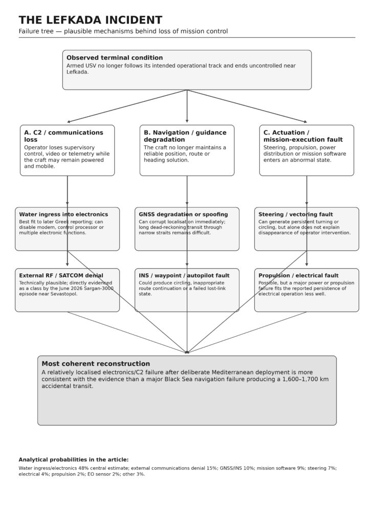
The most important distinction in the tree is between communications loss and navigation loss, because a vehicle that loses SATCOM but retains GNSS, INS and autopilot may remain entirely capable of navigating its stored route, whereas a vehicle that loses both navigation and steering coherence becomes genuinely uncontrolled. A MAGURA operator interviewed after the Ivanovets attack described pre-programmed navigation during much of the journey followed by human control closer to the target, demonstrating that Ukrainian USVs can retain meaningful mobility despite temporary absence of direct joystick control; therefore, “the operator lost communications” is not by itself enough to explain a 1,600-km geographic displacement, because one must also know what route remained stored in the autonomous mission manager. [21]
This is why the hypothesis of a small technical fault producing an enormous geographic error from the Black Sea is logically problematic: if only the communications link failed, the USV could continue a route, but the route would have to have been programmed towards the Mediterranean already; if GNSS and high-level navigation failed, completing two Turkish Straits and the subsequent Aegean-Ionian route becomes exceedingly improbable; if steering or propulsion failed, long powered transit becomes impossible; and if the USV merely drifted, its journey would depend upon currents and weather over a period so long that accidental landfall, detection or depletion of energy would become increasingly likely before arrival at Lefkada.
The Lefkada fault therefore need not have been “important” in the sense of a catastrophic systems failure; paradoxically, the available evidence is more consistent with a relatively localised failure — such as water penetration disabling a modem/control processor — occurring after a deliberate strategic deployment, because the platform retained enough functionality to remain electrically alive while no longer accomplishing its mission. From a systems-engineering perspective, this is not a case in which a gigantic malfunction explains a gigantic geographical deviation, but one in which the operational geography was probably already intentional and a comparatively prosaic fault converted an offensive platform into an uncontrolled maritime hazard. [5]
Transit feasibility and route reconstruction
A geographical reconstruction is particularly useful because it imposes physical constraints upon political narratives. Using representative sea waypoints rather than straight-line land-crossing distance, a Sevastopol-origin route through the Bosphorus, across the Sea of Marmara, through the Dardanelles and then south through the Aegean and around the Peloponnese to Lefkada is approximately 1,660 km, while an equivalent route beginning near Odesa is approximately 1,740 km; a route using the Corinth Canal could reduce the distance towards roughly 1,400 km from Sevastopol, but requiring an unidentified armed craft to transit such a controlled and highly confined waterway would make the accidental-transit explanation less, rather than more, credible.
The principal route stages are approximately:
| Route stage | Approximate maritime distance |
| Sevastopol to northern Bosphorus approach | 520 km |
| Odesa to northern Bosphorus approach | 600 km |
| Bosphorus transit | approximately 30 km |
| Sea of Marmara crossing | approximately 200 km |
| Dardanelles transit | approximately 60 km |
| Dardanelles exit to southern Aegean/Cape Malea region | approximately 470–540 km depending routing |
| Southern Peloponnese to Lefkada | approximately 300 km |
| Total from Sevastopol, conventional route | approximately 1,660 km |
| Total from Odesa, conventional route | approximately 1,740 km |
These route calculations are particularly consequential when compared against published platform envelopes. A MAGURA V5 with approximately 833 km publicly stated range would require about 200 per cent of nominal range to reach Lefkada from Sevastopol; the 2024 Sea Baby at 1,000 km would require approximately 166 per cent; even the October 2025 upgraded Sea Baby at more than 1,500 km would require roughly 111 per cent from Sevastopol and 116 per cent from Odesa, before any allowance for loitering, deviations, rough-water penalties or reserve. Mamai’s maximum speed of approximately 110 km/h cannot resolve the energy problem because maximum speed is not endurance speed and there is no sufficiently reliable public Mamai fuel/range figure from which to construct a credible 1,700-km budget. [22]
At MAGURA V5’s publicly reported cruise speed of approximately 41 km/h, a 1,660-km route would require around 40.5 hours of continuous progress, while 1,740 km would require approximately 42.5 hours; the platform’s sometimes quoted 60-hour “autonomy” therefore does not solve the discrepancy because endurance in time and range in kilometres measure different constraints, and a craft may have electronics capable of remaining active for 60 hours without carrying enough fuel to travel at cruise speed for the entire period. This is an important analytical correction because open-source discussion frequently treats endurance, range and autonomy as interchangeable parameters when, for a fast planing USV, the limiting variable is likely to change substantially with speed, sea state, payload and manoeuvring.
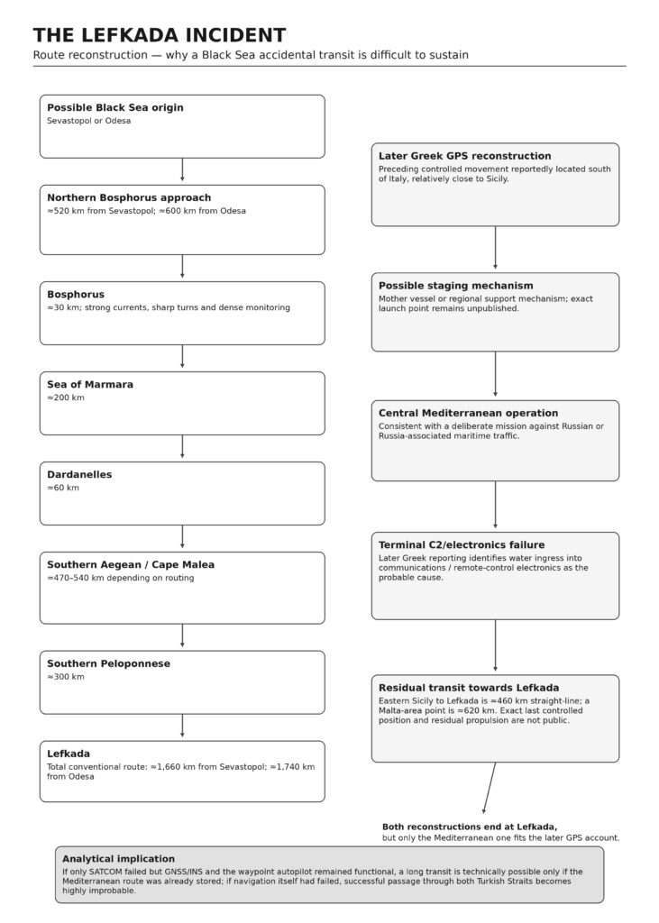
The navigational difficulty is at least as important as the energy budget. Türkiye’s Foreign Ministry describes strong currents, sharp turns and unpredictable weather changes as making the Turkish Straits among the world’s most difficult waterways for safe navigation, while the fact that the Bosphorus and Dardanelles are heavily monitored international shipping corridors further reduces the plausibility of a conspicuous uncontrolled armed craft fortuitously navigating the entire sequence without either purposeful guidance or detection. [23]
A degraded-mode assessment produces the following hierarchy:
| State after initial fault | Ability to reach Lefkada from Black Sea | Analytical assessment |
| SATCOM lost, GNSS/INS/autopilot fully functional, Mediterranean route already stored | Technically possible if fuel/range sufficient | This is not accidental geographic wandering; it implies that the mission plan already pointed out of theatre |
| SATCOM lost, autopilot retains only last waypoint/heading | Very poor | A fixed-heading solution cannot reliably negotiate both Turkish Straits and subsequently round Greece |
| GNSS lost, INS/dead reckoning remains available | Poor over >1,500 km | Accumulating position/heading error becomes increasingly severe in narrow waterways unless external aiding is restored |
| GNSS spoofed in a coherent fashion | Technically possible | Would imply sophisticated external manipulation rather than a random hardware fault |
| Steering failure | Extremely poor | Controlled transit of the Straits becomes implausible |
| Propulsion failure | Essentially passive drift | Cannot explain rapid purposeful passage; surface currents may assist some directions but cannot supply navigational intelligence |
| Major power failure | Negligible | Mission and long-range powered movement cease |
| Local C2 failure after Mediterranean deployment | High compatibility with Lefkada | Requires only the observed final deviation, not an extraordinary 1,600–1,700 km accidental journey |
The later Greek reconstruction effectively resolves most of this problem because, according to To Vima’s account of the completed Hellenic defence investigation, GPS evidence indicated that the Mamai approached Greek waters after operating in the maritime area south of Italy near Sicily, where it had been positioned either from a mother vessel or via a regional support mechanism; the same account attributed the eventual loss of control to water intrusion into the communications/remote-control electronics. [19]
That reconstruction does, however, leave one technical question open which should not be ignored simply because it appears in a government-sourced narrative: eastern Sicily to Lefkada is approximately 460 km in straight-line distance, while a point closer to Malta is roughly 620 km from Lefkada, meaning that a purely passive craft drifting at an average one knot would require approximately 10–14 days to cover those distances, at two knots roughly five to seven days and at three knots approximately three-and-a-half to five days. Since the public Greek account does not release the timestamp of the last valid controlled position, the exact current field, the craft’s speed-over-ground history or whether residual propulsion continued after C2 loss, the statement that “ocean currents carried it to Lefkada” cannot independently be verified from the public record; this is, in our view, the weakest technical element remaining in the later Greek narrative, although it is a much smaller difficulty than the original Black Sea-to-Lefkada accident hypothesis. [19]
There is also no contradiction between the craft having suffered a genuine communications fault and having been conducting an ambush-type anti-shipping mission, because these propositions concern different stages of the sequence. Ukraine had already demonstrated a willingness and capability to conduct strike operations against Russian-associated shipping far outside the Black Sea: Reuters reported that the SBU acknowledged a December 2025 aerial-drone attack against the Qendil in Mediterranean waters more than 2,000 km from Ukraine, describing it as the first Ukrainian operation of that type against a shadow-fleet tanker in the Mediterranean. [24]
Consequently, the Mediterranean anti-tanker hypothesis requires no speculative strategic revolution invented to explain Lefkada; the strategic precedent already existed, and the remaining question is whether this particular Mamai belonged to the same broader campaign.
Command, control and forensic evidence
The question of why Ukrainian operators did not track the Mamai, warn Greece or destroy it requires a distinction between knowing that a vehicle has disappeared from C2, knowing where it subsequently is, and retaining the technical capacity to issue a destructive or safing command, because these are three separate capabilities that are often collapsed into the generic term “tracking.”
In any normally supervised beyond-line-of-sight architecture, disappearance of heartbeat, telemetry and video should reveal link loss to the control station within seconds or minutes, making the probability that operators noticed the disappearance of a monitored craft very high unless the mission itself had entered a deliberately autonomous silent mode; what is not guaranteed is continuing position knowledge after the link disappears, because a stealth strike USV cannot be assumed to broadcast AIS, and if the platform’s only outbound telemetry travels through the communications path that has failed, the control team is left with the last valid fix unless a separate low-bandwidth tracker, satellite imagery, airborne ISR, coastal radar or intelligence network reacquires it.
For a controlled mission we would therefore assess the probability that the Ukrainian operator recognised loss of the primary command link at more than 95 per cent, while the probability of retaining accurate real-time location after a total link failure may have been only about 10–40 per cent depending upon whether an independent tracking channel or external ISR existed; these are engineering estimates rather than disclosed Ukrainian figures, but they explain why “they knew they had lost the drone” and “they knew exactly where it was several hours later” are not equivalent propositions.
The probability of executing a remote self-destruct after total communications loss is lower still, because a command cannot travel through a channel that no longer exists, meaning that destruction after lost link requires either an independent communications path or an autonomous pre-programmed rule. The October 2025 Sea Baby presentation confirms that at least some SBU platforms possessed capture-denial self-destruct functionality, while the Sargan-3000 incident proves much more specifically that the Ukrainian Navy could program an autonomous self-destruction interval which continued to run even after operators could no longer communicate with the USVs. [18]
Constanța is consequently the best available control case for interpreting Lefkada. According to the Romanian Ministry of National Defence’s detailed July statement, Ukraine lost communications with four Sargan-3000 USVs near Sevastopol during the afternoon of 4 June and could no longer control their trajectories or restore communications; on the morning of 5 June, at 09:54, the Ukrainian Navy informed the Romanian Navy that the drones constituted a danger because they were entering their programmed self-destruction interval, while loss of communications made cancellation impossible. Romania had already detected the object at Berth 78 at 06:20, the craft inside Constanța exploded at approximately 10:30, a second exploded outside the port around 11:00, and the remaining two were subsequently confirmed destroyed offshore, after which Bucharest requested a permanent technical communication mechanism and future programming that would cause Ukrainian USVs entering Romanian areas to self-destruct in safe zones instead. [8]
That chronology demonstrates four facts which are directly relevant to Lefkada: Ukraine is technically capable of detecting that communications with its USVs have been lost; lost communications do not necessarily mean that the platform stops navigating; autonomous self-destruct functions exist on at least some Ukrainian USV architectures; and, most importantly from a governance perspective, Ukrainian warning procedures were not sufficiently immediate to ensure that the allied coastal state always learned about the hazard before detecting it independently. [3]
Mamai cannot be assumed to share Sargan’s self-destruction logic, since the systems belong to different programmes and operators, and the public record contains no technical manual showing that the Lefkada configuration possessed either an autonomous lost-link destruct timer or a separate emergency communications channel. Greek reporting instead states that the craft remained electrically operational for approximately ten hours after discovery, that no operator manoeuvred it away while fishermen and authorities attempted to secure it, and that its explosive triggering mechanism had not been activated, which is entirely compatible with a dead primary communications link combined with no autonomous capture-denial action. [25]
The cave location itself may have compounded that problem, because a craft that enters or becomes trapped beneath rock cover can lose both useful GNSS geometry and satellite-communications visibility, so even a platform whose communications hardware remained intermittently alive might become unrecoverable once inside the cave; this does not prove that the cave was accidental, but it makes the cave an unattractive deliberate long-duration SATCOM-controlled ambush site unless another communication architecture or external relay was available.
The sequence of public forensic reporting deserves careful weighting because the story evolved rather than remaining constant:
| Date | Public evidence | Analytical importance |
| 7–8 May | Fishermen found the armed USV in a Lefkada coastal cave; early Greek specialists compared it with MAGURA designs, while UForce later rejected the MAGURA identification | Establishes discovery but shows why visual platform attribution is unreliable. Reuters later corrected the model identification. [26] |
| 11 May | To Vima, citing initial GPS and battery analysis, reported an apparent Ukrainian launch from a vessel operating in the Ionian area, a probable Russian commercial target, continued electrical activity for about ten hours and absence of operator intervention | Early evidence already pointed toward a Mediterranean mission rather than Black Sea drift, although investigators explicitly described the findings as preliminary. [25] |
| 12 May | Greek Defence Minister Nikos Dendias said Greece was certain that the USV was Ukrainian and described the explosives-carrying craft as a serious navigation-security problem | Upgraded provenance from speculation to Greek government attribution. [27] |
| 15 May | Reuters reported that investigators believed the craft had lost orientation because of technical malfunction, were reverse-engineering it and analysing metadata, and were considering mother-ship or coastal launch scenarios while encrypted material remained unresolved | Strong independent reporting for a genuine malfunction, but investigation still incomplete. [28] |
| 20 May | To Vima reported that the completed defence investigation identified a Mamai, traced preceding GPS movement to the area south of Italy near Sicily and attributed loss of C2 most probably to water intrusion in electronics | Most technically consequential public reconstruction, although the underlying official report itself remains classified/unpublished. [19] |
| 3–4 June | Greece confirmed two diplomatic démarches and explicitly complained that Ukrainian USV activity represented an extension of military operations into the Mediterranean | Very difficult to reconcile with Athens believing the drone had simply drifted from an ordinary Black Sea mission. [29] |
| 5–6 June | Ukraine apologised and affirmed its interest in preventing recurrence, while also referring to maritime-security concerns associated with Russia’s shadow fleet | De facto political acceptance of responsibility after earlier uncertainty. [30] |
| 5 June / 3 July | Four Sargan-3000 USVs lost Ukrainian C2 near Sevastopol; one detonated in Constanța and Romania later released the detailed Ukrainian explanation and revised procedures | Provides the strongest public comparator for real Ukrainian lost-link and self-destruct behaviour. [8] |
The changes between 11, 15 and 20 May should not be treated as evidence of deception by themselves, because forensic analysis routinely changes hypotheses as logs are decoded and fuel/electrical data are correlated; indeed, the early To Vima theory placed the launch relatively near the Ionian islands, Reuters then reported that investigators believed the craft had not travelled a very long distance, while the later Greek account moved the preceding controlled area westward towards southern Italy/Sicily. [31]
What did not change is more important: each increasingly mature version of the Greek investigation moved away from the idea that an ordinary Black Sea sortie had simply wandered all the way to Lefkada, while the formal Greek diplomatic response ultimately characterised the incident as Ukrainian military activity in the Mediterranean. [29]
Competing hypotheses and diplomatic sanitisation
The competing hypotheses can be assessed against a small number of high-value indicators rather than against political preference: the recovered platform’s technological provenance, GPS history, residual fuel and electrical state, last valid C2 timestamp, navigation-mode history, explosive safing state, evidence of water ingress, existence of a pre-programmed target or loiter box, the identity of any satellite terminal, and the presence of Russian or Russia-associated shipping along the reconstructed mission corridor.
Deliberate Mediterranean anti-shipping mission followed by genuine failure
This is the strongest hypothesis because it simultaneously explains why the craft was already in the central Mediterranean, why Greece later protested against the geographical expansion of Ukrainian military activity, why Ukrainian diplomacy ultimately apologised, why Greek investigators considered Russian commercial shipping as a possible target, and why the physical vehicle nevertheless ended up harmlessly but dangerously trapped at Lefkada. Ukrainian strategy had already expanded to Russian-linked commercial shipping before this incident, including the SBU-acknowledged Qendil strike in Mediterranean waters more than 2,000 km from Ukraine and multiple Sea Baby strikes against Russian-associated tankers in the Black Sea. [32]
The probability we assign to this combined hypothesis — deliberate Mediterranean deployment plus subsequent genuine technical failure — is approximately 70 per cent, with a plausible 60–80 per cent range and medium-high confidence.
Deliberate loitering or ambush without a material fault
A Mamai could theoretically have been pre-positioned in the Ionian or central Mediterranean to wait for a Russian vessel, especially because concealment near a coastline reduces visual detection and because a low-profile USV can exploit civilian traffic and coastal clutter; however, deliberate parking inside a cave is technically less attractive for a platform dependent upon satellite navigation and beyond-line-of-sight communications, while the Greek report of water-contaminated electronics, circular movement and lack of operator response all favour real loss of control over deliberate silent loitering. [5]
We consequently assign only around 10 per cent to a predominantly deliberate ambush/loiter hypothesis in which the reported fault was not materially responsible for the final location, while recognising that a deliberate holding mission and a later real fault are not mutually exclusive and are already partly captured inside the principal 70 per cent hypothesis.
Black Sea fault followed by long accidental transit
This requires the greatest number of technically inconvenient assumptions, because either the vehicle retained enough navigation intelligence to negotiate approximately 1,600–1,700 km of complex routing, in which case it was not truly navigationally lost, or it lost meaningful navigation, in which case completing the Bosphorus, Marmara, Dardanelles, Aegean and Peloponnese sequence fortuitously becomes extremely improbable; the range problem compounds the navigational problem, and the later Greek GPS reporting directly contradicts the premise that the craft’s relevant preceding trajectory originated in the Black Sea. [33]
We assign this hypothesis approximately 3 per cent, and would reduce it further if the Greek raw GPS reconstruction were independently published.
Capture-and-reuse or false flag
Technically, capture and reuse are plausible because the Ukrainian systems rely substantially upon commercial propulsion, communications and sensor technology, and the proliferation of maritime-drone designs means that external appearance cannot establish current operator identity; RUSI has emphasised precisely the COTS-heavy character of the technology, while the initial Lefkada misidentification as a MAGURA demonstrates the danger of visual attribution. [34]
Politically, however, a false-flag explanation for Lefkada presently lacks positive evidence, because Greece concluded that the system was Ukrainian, its technical teams apparently extracted mission history from onboard systems, Athens then confronted Kyiv rather than Moscow, and Ukraine subsequently apologised rather than maintaining that the craft had been stolen or cloned. [2]
We therefore retain approximately 3 per cent for capture/reuse/false flag, not because the mechanism is impossible but because there is presently no public indicator supporting it in this case.
Diplomatic and intelligence sanitisation
Here the answer requires greater precision than the politically loaded word “cover-up” permits, because there are at least three different propositions which should not be conflated.
The probability that Greece has withheld significant operational and forensic detail is, in our assessment, approximately 85–95 per cent, not because there is evidence of misconduct but because no competent defence ministry would normally publish raw navigation histories, cryptographic data, satellite terminal identifiers, signal-intelligence correlations, suspected covert launch vessels or exploitable vulnerabilities extracted from an adversary or partner’s recovered weapon; Reuters itself reported that Greek intelligence and military specialists were dismantling and reverse-engineering the craft and attempting to decode encrypted information. [28]
The probability that Ukraine has withheld the real operational objective, launch/support architecture and target is similarly very high if the mission was Ukrainian, because disclosing a Mediterranean mother ship, Libyan support point, covert satellite architecture or Russian tanker surveillance chain would compromise future operations; the later Greek press account explicitly referred to a possible mother-vessel or regional support mechanism and the formal Greek protest referred to military activity in the Mediterranean, while Kyiv’s apology carefully accepted the safety problem without publicly describing a target or command chain. [35]
The much stronger proposition — that Greek and Ukrainian officials jointly invented a technical malfunction in order to conceal a deliberately parked ambush craft — is less persuasive, for which we would assign approximately 10–25 per cent, because Greece had little political incentive to protect Kyiv completely and in fact publicly escalated the issue, while the water-ingress explanation emerged from Greek technical sources rather than solely from Ukrainian diplomacy. [36]
In other words, selective disclosure is almost certain, a sanitised public account of the mission purpose is highly plausible, but fabrication of the physical fault is presently unproven and is not necessary to explain the available evidence.
The classified evidence most likely to settle the issue would include the full GPS/NMEA history and waypoint database; IMU and navigation-filter logs; timestamps of the last successful operator command and last acknowledged telemetry packet; satellite-terminal serial, subscriber and beam-session records; RF modem logs; command-station authentication artefacts; engine hours and residual fuel; bilge/water-ingress sensor history if fitted; ECU and power-bus fault codes; mission-state-machine transitions; geofence and return/loiter behaviour; the explosive arming and self-destruct configuration; camera or video buffers; component serial numbers; cryptographic keys or certificates; and external intelligence correlating the platform’s last controlled position with candidate mother ships and Russian-associated tanker tracks.
For an analyst familiar with autonomous systems, the single most decisive field would probably not be GPS position alone but the correlation between last-command timestamp, navigation-mode transition and waypoint queue, because that sequence would show whether the craft was being actively driven towards a Russian vessel, executing a pre-programmed loiter box, continuing autonomously after lost link, or merely drifting after the guidance computer became ineffective.
The most important evidentiary discriminator is therefore straightforward: if the mission file contains Mediterranean waypoints or a target/loiter region south of Italy before the first recorded communications fault, then the “fault brought it into the Mediterranean” proposition is conclusively false even though the subsequent “fault brought it to Lefkada” proposition may be true; conversely, if the stored route ends in the Black Sea and the navigation log subsequently shows an extraordinary uncontrolled sequence through the Turkish Straits, then the accident hypothesis would deserve radical upward revision.
Nothing publicly released so far points towards the second scenario.
Operational implications and bibliography
The immediate operational lesson is that friendly-origin unmanned weapons must be treated as cross-border hazardous systems rather than merely as national weapons after launch, because a platform that loses C2 can continue travelling for hours and, as Constanța demonstrates, can enter an allied commercial port before its programmed termination logic activates. Romania’s subsequent demand for a permanent Ukrainian technical channel and safe-zone self-destruction programming is therefore not bureaucratic housekeeping but the beginning of the doctrine that NATO states should have required once long-range autonomous weapons began operating adjacent to allied territorial waters. [8]
A NATO-compatible lost-link protocol should require that once a weaponised USV has remained outside positive supervisory control beyond a defined interval and its uncertainty ellipse can intersect allied territorial waters or major civilian shipping corridors, the launching authority immediately transmit to designated maritime coordination centres a minimum incident packet containing platform family, last known position and timestamp, heading and speed, predicted uncertainty area, remaining endurance, explosive state, lost-link mode, self-destruct or scuttling deadline and any reason to suspect GNSS/EW manipulation; disclosure of the target need not automatically be required at the first technical-warning stage, but the safety data cannot reasonably remain compartmented once an uncontrolled explosive system poses a foreseeable risk to allied civilians.
The fail-safe architecture itself should also distinguish between denial to an enemy and safety in friendly waters, because an automatic high-explosive self-destruction function that is rational near Sevastopol can become precisely the wrong response inside Constanța, Piraeus or an LNG approach channel. A mature architecture should therefore use geographic and mission-state logic in which loss of link inside a verified hostile engagement box may permit autonomous scuttling or destruction, whereas entry into recognised allied or neutral safety areas should first safe the warhead, terminate propulsion where doing so does not increase collision risk, activate a low-power emergency beacon through an independent channel and permit controlled recovery; explosive destruction should remain a final option in a validated safe maritime area rather than an indiscriminate default.
The C2 system should similarly avoid making the primary high-bandwidth video/control bearer the only route through which an emergency safing instruction can be issued, because the Sargan precedent demonstrates the obvious architectural problem: once the normal communications link disappeared, the operator could not cancel the already programmed self-destruction. A geographically separated, low-bandwidth emergency channel with independent authentication would not guarantee connectivity, but it would reduce the probability that loss of the principal SATCOM/RF path simultaneously destroys command, telemetry, tracking and emergency-safing capability. [8]
Forensics should become standardised at NATO/EU level, with recovered military USVs treated in the same way that aviation authorities treat flight-data evidence, because attribution increasingly depends upon reconstructing software state rather than merely inspecting hull shape. A minimum forensic package should preserve bit-for-bit mission-computer images, navigation data, modem logs, signed command records, time synchronisation, fuel and battery state, warhead safing status and radio-frequency identifiers before national services begin destructive exploitation, after which sanitised findings can be shared rapidly with allies while the raw intelligence remains restricted.
Counter-USV defence around civilian ports should emphasise persistent detection and controlled interdiction rather than simply adding more kinetic weapons, because RUSI has correctly noted that littorals and maritime chokepoints provide USVs with their most favourable operating environment, while NATO’s Task Force X-Baltic tested approximately 70 aerial and maritime unmanned systems between March and October 2025 precisely to improve persistent maritime awareness alongside conventional assets. [37]
For major Mediterranean facilities, an effective layered system therefore requires fusion of coastal radar, electro-optical/infrared sensing, passive RF detection, harbour cameras, commercial traffic data and autonomous patrol systems with physical barriers and specialised interception assets, while the decision software must distinguish an anomalous two-metre craft from legitimate fishing and leisure traffic without requiring a frigate to investigate every return; this is fundamentally an information-fusion problem before it is a weapons problem.
The legal and political response thresholds likewise need to be separated from final attribution. Hybrid CoE’s work on maritime infrastructure argues that states possess broad authority to maintain maritime situational awareness but face a more fragmented legal framework when operational action is required, particularly outside territorial waters, which means that waiting for courtroom-level attribution before implementing protective measures gives the ambiguous actor an unnecessary advantage. [38]
For NATO and EU purposes, the presence of an unidentified armed USV approaching a port or critical infrastructure should therefore trigger a common maritime-security incident procedure based upon capability and behaviour rather than presumed nationality; attribution to Ukraine, Russia or a third actor can develop subsequently, while immediate actions — traffic separation, explosive-ordnance response, surveillance, data preservation and allied notification — should not depend upon resolving the political question first.
For Ukraine specifically, the strategic lesson should be equally direct: a successful unmanned-warfare campaign that imposes disproportionate costs on Russia can nevertheless create unacceptable externalities when its weapons migrate into allied ports or territorial waters, and support for Ukraine does not require European governments to pretend otherwise. Greece’s protest and Romania’s subsequent technical demands are rational actions by allies whose governments carry legal responsibility for civilian shipping and national territory, and Kyiv’s own long-term interest lies in making its increasingly long-range autonomous force predictable to partners even while preserving operational secrecy from Russia. [39]
The most consequential conclusion for the Lefkada case is therefore that the probability of a fault is not the point on which the deliberate-Mediterranean-operation hypothesis fails; on the contrary, a genuine fault is entirely plausible and is positively supported by the Greek forensic reporting, but that fault appears to have occurred after the drone had already been deliberately placed hundreds or perhaps more than a thousand kilometres from the recognised Black Sea theatre. [19]
A machine failure can explain why the Mamai missed its target, lost contact with its operator, moved unpredictably and ended at Lefkada, while it cannot plausibly explain, on the evidence presently available, why an armed Ukrainian Mamai was operating in the central Mediterranean at all.
The danger, thus, is not that Ukrainian autonomous weapons are so unreliable that they can accidentally navigate from Crimea to Greece, which would actually be a technically dubious proposition, but that the operational geography of Ukrainian unmanned warfare has already extended into the Mediterranean, where a perfectly ordinary failure of one component or communications path can transform a covert weapon directed against an adversary into an uncontrolled explosive hazard for an allied state.
Bibliography
Associated Press (2026a) ‘Authorities probe mystery military sea drone washed ashore on Greek island’, Associated Press, 8 May 2026.
Associated Press (2026b) ‘Greece says attack sea drone found on island is Ukrainian, calls incident “extremely serious”’, Associated Press, 12 May 2026.
Blackburn, G. (2025) ‘Ukraine unveils upgraded “Sea Baby” drone it says can strike anywhere in the Black Sea’, Euronews, 23 October 2025.
Hellenic reporting via Kathimerini (2026a) ‘Athens lodges protest with Kyiv over drone’, Kathimerini, 4 June 2026.
Kathimerini (2026b) ‘Ukraine apologizes to Greece over naval drone’, Kathimerini, 6 June 2026.
Kaushal, S. (2023) ‘Ukraine’s Uncrewed Raid on Sevastopol and the Future of War at Sea’, Royal United Services Institute, 2 February 2023.
Kaushal, S. (2024) ‘Uncrewed Platforms Have Been Critical to Ukraine’s Success in the Black Sea’, Royal United Services Institute, 20 August 2024.
Kaushal, S. and Louth, J. (2026) Prototype Warfare in the Maritime Domain: Opportunities and Approaches. London: Royal United Services Institute.
Lambropoulos, V. (2026) ‘Lefkada: What the Drone’s GPS Tells About Its Origin’, To Vima, 11 May 2026.
Ministry of National Defence of Romania (2026) ‘Răspunsul părții ucrainene referitor la incidentul din Portul Constanța din 5 iunie 2026’, Press Release No. 191, Bucharest, 3 July 2026.
NATO (2026) ‘NATO Allies agree to expedite innovation adoption and integration for Baltic Sea security’, North Atlantic Treaty Organization, 12 February 2026.
Reuters (2025) ‘Ukraine hits Russian shadow fleet tanker in Mediterranean for first time, SBU source says’, Reuters, 19 December 2025.
Reuters (2026a) ‘Greece investigating Ukrainian-made naval drone found in cave on island’, Reuters, 8 May 2026, corrected 12 May 2026.
Reuters (2026b) ‘Greek probe finds suspected Ukrainian sea drone lost course after malfunction, sources say’, Reuters, 15 May 2026.
Reuters (2026c) ‘Ukrainian sea drone self-destructs near oil terminal in Romanian port’, Reuters, 5 June 2026.
Sari, A. (2025) Protecting Maritime Infrastructure from Hybrid Threats: Legal Options. Hybrid CoE Research Report 14. Helsinki: European Centre of Excellence for Countering Hybrid Threats.
Sutton, H.I. (2025) Overview of Ukrainian Maritime Drones of the Russo-Ukrainian War. Covert Shores, updated 30 September 2025.
Tyschchenko, K. and Romanenko, V. (2023) ‘Ukraine’s Security Service on Mamai naval drone: Fastest object in Black Sea’, Ukrainska Pravda, 24 December 2023.
Türkiye Ministry of Foreign Affairs (2026) ‘Note on the Turkish Straits’. Ankara: Republic of Türkiye Ministry of Foreign Affairs.
UNITED24 (2024) ‘This is Battleship: Sea Baby naval drone programme’. Kyiv: Official fundraising platform of Ukraine.
Gkaziamis, M. (2026) ‘Greek Report: Kamikaze Drone Came from Southern Italy’, To Vima, 20 May 2026.
[1] [28] Greek probe finds suspected Ukrainian sea drone lost course after malfunction, sources say | Reuters
[2] [29] [39] https://www.ekathimerini.com/politics/foreign-policy/1305587/athens-lodges-protest-with-kyiv-over-drone/
[3] [8] [15] [20] https://www.mapn.ro/cpresa/19299_Raspunsul-par%C8%9Bii-ucrainene-referitor-la-incidentul-din-Portul-Constan%C8%9Ba-din-5-iunie-2026
[4] [17] [34] [37] https://www.rusi.org/explore-our-research/publications/commentary/ukraines-uncrewed-raid-sevastopol-and-future-war-sea
[5] [16] [25] [31] https://www.tovima.com/society/lefkada-what-the-drones-gps-tells-about-its-origin/
[6] [12] https://www.hisutton.com/Ukrainian-USVs-Russo-Ukraine-War.html
[7] [10] [21] https://www.businessinsider.com/ukraine-sea-drones-with-jet-skis-sink-russia-ship-ivanovets-2024-2
[9] https://www.rusi.org/explore-our-research/publications/research-papers/prototype-warfare-maritime-domain-opportunities-and-approaches
[11] [22] https://www.pravda.com.ua/eng/news/2023/12/24/7434442/
[13] https://u24.gov.ua/seababy
[14] [18] https://www.reuters.com/world/europe/ukraines-sea-baby-drones-are-growing-up-with-longer-range-bigger-payload-2025-10-22/
[19] [35] [36] https://www.tovima.com/politics/greek-report-kamikaze-drone-came-from-southern-italy/
[23] [33] https://www.mfa.gov.tr/the-turkish-straits.en.mfa
[24] [32] https://www.reuters.com/business/aerospace-defense/ukraine-hits-russian-shadow-fleet-tanker-mediterranean-first-time-sbu-source-2025-12-19/
[26] Greece investigating Ukrainian naval drone found in island cave | Reuters
[27] https://apnews.com/article/c51b74a4472ab60411b330515eadf5e8
[30] https://www.ekathimerini.com/politics/foreign-policy/1305905/ukraine-apologizes-to-greece-over-naval-drone/
[38] https://www.hybridcoe.fi/wp-content/uploads/2025/03/20250306-Hybrid-CoE-Research-Report-14-web.pdf